IN THE GASTELS LAAG, THE NETHERLANDS
Dr K.A.H.W. Leenders, The Hague
You can visit the Gastels Laag. You will not see any historical traces. It is now a naturespot in the making. Further information (in Dutch)
INTRODUCTION
In a small sinus on the inner rim of the coastal plain in the Low Countries the succession of land use phases has been documented. This is the result of rather rudimentary documentation of remains found in the field, done in 1995 with the help of students from Ghendt University and the institute THO in Tilburg. A full report is published as Leenders, 1995.
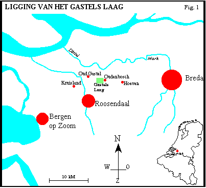
The studied terrain lies in a depression (-0.5 m N.A.P.), the "Gastels Laag", between a ridge of coversand on old Pleistocene clays (+3 m), called "Kuivezand", and an higher outcrop of that old clays (+6 m) called the "Heinsberg". The depression is connected with a further depression to the south, but the terrain rises slowly in that direction. To the north-east the depression had a open connection with the coastal plain proper (Verbraeck and Bisschops, 1971; Soil maps 1:50.000, sheets 43 O and 49 O; See figure 2 .). The Gastels Laag is situated 1 to 2 kilometers southwest of the village of Oudenbosch, but it is named after the village of Oud-Gastel, to which it belongs. See figure 1
In the Gastels Laag 10 land use phases were detected and dated:
BEFORE 1289 : NATURAL PEATLAND
Before the first medieval human diggings the Gastels Laag was filled with a layer of peat. The top of the peat may have reached to 2 m above sealevel, with a thickness in the centre of about 3.0 to 3.5 meters. To the northeast the peat was connected with the "Hollandpeat" of the coastal plain. To the south the peat was connected to more inland-type peatlands. The lowest layer of peat in the Gastels Laag is a black homogenous peat with some stumps of trees standing or laying horizontally. The higher layers were removed after 1289. In the coastal plain the influence of the sea was at this point till 1288 insignificant, but a floodsurge in february 1288 brought salty seawaters for a short time up to 2 kilometers from the Gastels Laag. Later in the Middle Ages the sea would eventually even reach the Gastels Laag itself.
1289 - 1330 : DIGGING OF TURFS
Starting in 1245, the reclaimation and forming of new settlements gained much momentum in this part of the Low Countries. As a part of this in 1264 large scale commercial peatdigging started, initiated by the need for household and industrial fuel in the then flourishing Flemish cities of Ghendt, Bruges and others. At first the peatlands were sold to Flemish investors, but lateron also to entrepreneurs and institutions from this Brabant region itself (Leenders, 1989). One of these was the Norbertin convent of St. Catharinadal. This convent had been founded in 1271 on a coversand ridge directly on the rim of the coastal plain, 6.5 km southwest of the Gastels Laag. The farming lands of the convent were partly drowned in the flood of 1288. On september 10, 1289 this convent became the owner of 150 hectares (350 acres) of peatlands, heather and wilderness in and around the Gastels Laag (Erens, 1928 - 1931, nr. 21). In the same years also the neighbouring peatlands were sold to people from Flanders and Brabant. The large scale peatdigging could start.
Peatdigging is not an typical activity of Norbertin nuns. However, competent help was locally available. The name of one of the little paths into the Gastels Laag, "Munniken Straatje" suggests that one of the monasteries active in the region in fact organised or actually did the digging in the Gastels Laag. This digging probably started in 1301. In that year the newly dug harbour canal of Baarlebosch (now: Oudenbosch) came into use (Unpublished charters of june 24, 1301 and february 2, 1302). From there the turfs could be shipped to Flanders or elsewhere in Brabant. The habour was also the best place to discharge the drainagewater that flowed through a short canal from the peatlands of the Gastels Laag to that harbour.
Remains in the field, observable over 12 hectares (28 acres), showed that peatdigging was done by working on a horizontal level. Long straight and parallel lines were cut, forming 78 to 129 centimeters wide strips. These strips were then divided in transverse strips that were further cut into squares of about 15 x 18 centimeters. In the last stage cubic turfs were cut out and laid to dry in the sun and the wind. More or less cubic turfs are also known from statues in museums and churches in the region. Mostly a flat cutting tool was used, but also traces of the use of a slightly bent tool were seen. It proved very difficult to make the long straight lines of the long strips with such a tool.
1330 - 1421 : FRESH WATER LAKE
In the end a peatlayer of at its most 2.5 meters thick was dug away. It is uncertain how long that would take, but it could be done in 10 to 20 years. When peatdigging stopped, still up to 90 centimeters of good quality peat remained in the Gastels Laag. So the question arises why did peatdigging stop when there is still peat left? Digging stopped at a level of 60 centimeters below sealevel. This was really a accurate horizontal end-level. Even the laser guided excavator didn't manage in 1995 to produce a better result! Around 1300 - 1320 the famous Dutch polderwindmill had not yet been invented, so drainage had to be done by letting out the water at low ebb in the harbour of Oudenbosch. As became clear while investigating the Gastels Laag, further digging becomes inpossible when the waterlevel is higher than 80 to 70 cm below sealevel. In this way we found a low tide level for Oudenbosch in 1320: -80 cm.
After the commercial peatdigging stopped and the drainagesystem was not longer kept in good condition, the Gastels Laag became a inland fresh water lake. This prevented its use for grazing and the trampling of the weak traces of the peatcutting era that were visible so clearly in 1995.
1421 - 1425 : TIDAL, SEDIMENTATION OF CLAY
After the flood of 1288, the peatland in the coastal plain has been used on a greater scale than before for the production of salt. By digging out the peat for the production of turfs and salt the level of the terrain was lowered. This resulted in a slow ingressing of the sea, coming further eastward with each big storm surge. The speed of this process was estimated for this region at 45 kilometers per century (Leenders, 1986). This process culminated in the big storm surges of 1421 and 1424. Flooding came right into the middle of the Netherlands.
In 1421 or 1424 the sea water breached the dike-like road from Oudenbosch to Kuivezand. A big pool (named: "De Groote Weel") formed there, with a diameter of 350 meter (10 hectare, 25 acres). Sand from this pothole spread out in a fanlike manner into the Gastels Laag. During some time the tides could reach the Gastels Laag and a shallow layer of clay was deposited, only up to 10 centimeters thick. This layer gave the fragile traces of the peatdigging further protection.
1425 - 1583 : PARCELLATED MEADOW WITH FARMERS PITS
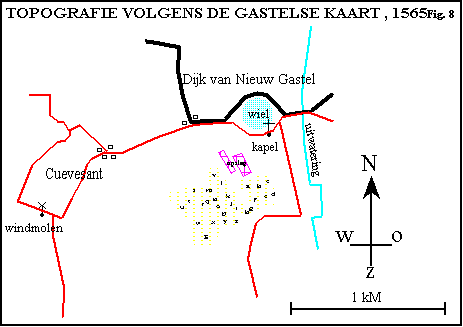
After quite a short time a new sea-dike was build along the northside of the Groote Weel, connecting the Kuivezandridge with the dike along the Oudenbosch harbour. The old road was repaired and laid along the southbank of the Groote Weel. The Gastels Laag was drained again and a new parcellation was laid out, at least in the northern part of it. The ditch called "Bansloot" became the main drainage channel, flowing to the Oudenbosch harbour. The terrain was reclaimed from the hamlet of Kuivezand as a meadow-area for growing hay and grazing cattle afterwards, as the older meadows on the rim of the coastal plain were now lost to the sea. See figure 8
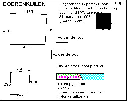
But even as meadow the Gastels Laag was not promising. So the farmers made a second use of it. They dug "farmers pits" in their meadows, to make their own household fuel. In summer a group of man dug out during one day as much peat as they could: the next day the pit would be full of water. After drying in the sun and the wind the turfs would be ready for use in the autumn. The farmers pits we found in 1995 cutting through the remains of the commercial peatdigging, measured 3 by 4 to 4 by 5 meters. They were dug, but in some it seems that the deeper peat was scooped out after the pit filled with water. We calculated that for feeding the hearths of the Kuivezand farmers for 150 years farmers pits over 23 hectares would be needed. That is twice the area now investigated, but it is about the area with peat-remains in the subsoil. See figure 9.
The farmers left the pits open, they didn't fill them in again. A vegetation of mainly reeds took over. The remains of this vegetation were found back in 1995 as vertical, very lose, "peat"-layers. After some time the Gastels Laag became a dangerous terrain, only accessible for people who knew the place very well.
1583 - 1605 : WILDERNESS
The Dutch revolt against the Spanish king led to the Eighty Year' War (1568 - 1648). For this region especially the period 1583 - 1609 proved disastrous. In 1583 Spanish and Dutch armies marched through the region, repeatedly plundering and burning down villages and farms. Even the new seawalls (1551) around Oud-Gastel were breached by the armies. The inhabitants fled to the cities and the countryside was left empty and free for further plunder. So the Gastels Laag, already more or less a wilderness, became even more an inaccessible marshy terrain, as the drainage system must have come to a complete halt.
1605 - 1615 : FILLING OF PITS, COVERVING WITH SAND
From 1594 onwards some repair was done. First the dikes were repaired, later followed by the main buildings in the villages. But only from 1604 onwards was normal life slowly restored. The wind-corn-mill of Kuivezand was rebuild in 1606, the churchtower of Gastel in 1607/8. The Twelve Year Truce (1609 - 1621) even made possible an economic revival of the region. Presumable during this period the farmers pits in the Gastels Laag were filled in. In the pits a mixture of clay and sand, with a lot of rubble and 16th / 17th century sherds was found. Some fields got a general but thin sandcover, brought up from the sandy ridge of Kuivezand. This covering with sand to improve the fields went on also in later centuries. The Gastels Laag became meadowland again.
1615 - 1850 : PARCELLATED MEADOW
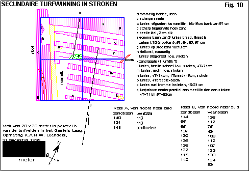
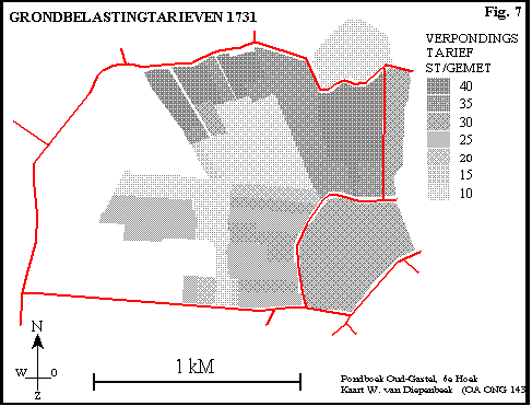
Never the less the old problem of bad soil and attractive peat in the subsoil was not really solved. Even some new elongated pits were dug, but these were now quickly filled in with sand. See figure 10. The farmers didn't do much maintainance work on the low-valued fields and ditches. In 1731 some fields were described as reedmarshes. The ditches were so wildly overgrown, that surveyor Van Diepenbeek could not see the boundaries between the fields. The deepest part of the Gastels Laag gave, according to his cadastral maps, the lowest landtax of the whole parish of Gastel.
From the work of Van Diepenbeek we know that most farmers of Kuivezand had some fields in the Gastels Laag. The big farm on the neighbouring Heinsberg had 36.5 hectare (85 acres). The nobleman Guilliam and Henri Proost had collected a number of fields as a part of their attempt to build a hugh new estate in Gastel. See figure 7.
1850 - 1995 : PARCELLATED MEADOW, IMPROVED DRAINAGE
In the middle of the 19th century the production of brick hollow drainage pipes became possible, after the invention of a machine that could press hollow clay pipes. From 1851 onwards the still very costly brick drainage pipes came into use at rich farms on good claysoils in the Dutch provinces of Groningen and Zeeland. Also in nearby Belgium these pipes were produced. Due to their high cost, they were at first only used to improve the drainage of already very valuable lands (Addens, 1952).
But the news of this invention must have reached the farmers around the Gastels Laag. The most probable route is by the mouth of the agricultural advisers that visited the villages in this period and gave instructions to the farmers (Crijns and Kriellaars, 1987). But the brick pipes were far to costly. In the Gastels Laag, on the poorest and wettest soils of the region, we found in 1995 the remains of wooden drainage pipes. They were made of young pine trees that were cut into halves. The halves were hollowed out and then bound together again to form a pipe. The pipes were used to drain the shallow trenches that were dug over the fields while keeping a level path along the side of the field. The wood of the pipes was C-14 dated : 145 ± 25 BP (GrN-22128).
Further drainage improvement followed around 1900, when the brick drainage pipes became affordable for the farmers who used them on more places in these wet soils.
1995 AND LATER : ABRASION OF SAND, BUILDING OF "NATURE"
In the framework of a land consolidation project the wet and bad lands of the Gastels Laag were brought together in the hands of "Staatsbosbeheer". This organisation planned to "build nature" in the lowest part of the Gastels Laag, as is now usual in such projects in the Netherlands. It was thought nessecary to remove all the "new" layers that covered the remaining peatlayer. This work was carried out during the hot and dry summer of 1995. The "new nature" would be developed on the very unnatural top of that peat: the last workfloor of a commercial 14th. century peatcutting operation.
Thanks to this removal of the topsoil over 12 hectares the multi-phase landscape history of this little part of the Low Countries became readable.
CONCLUSION
With quite simple means it proved possible to unravel a very complex landscape history that covered seven centuries. It must be noted that the studied terrain was never inhabitated and was never used to bury the dead. It was just a part of the countryside and (after ca. 1320) even a part with a very low value. Nevertheless, alongside the local landscape history, this studie produced more generally important data about the sea-level around 1300 and the working methods in the 14th century commercial and later farmers' peatdigging. It even brought us hitherto unknown information about 19th century innovative drainage methods on poor soils. Landscape archaeology holds much promise when it can be done on a higher level than was possible for myself and my friends in 1995!
REFERENCES
Addens, N.G. (1952) 'Een eeuw drainage in Groningen' in Groningse Volksalmanak 90 - 122.
Crijns, A.H., F.W.J.Kriellaars (1987) Het gemengde landbouwbedrijf op de zandgronden in Noord-Brabant 1800 - 1885, Tilburg.
Erens, A., ed. (1928 - 1931) De oorkonden van het norbertinessenklooster St. Catharinadal te Breda-Oosterhout, Tongerlo.
Leenders, K.A.H.W. (1986) 2000 jaar kustontwikkeling van Cap Gris Nez tot Hoek van Holland, Rijswijk. (Rijkswaterstaat rap.nr. NZ-N-86.19).
Leenders, K.A.H.W. (1989) Verdwenen Venen. Een onderzoek naar de ligging en exploitatie van thans verdwenen venen in het gebied tussen Antwerpen, Turnhout, Geertruidenberg en Willemstad. 1250-1750, Brussel / Wageningen.
Leenders, K.A.H.W. (1996) Landschapsgeschiedenis van het Gastels Laag, Tilburg. (Staatsbosbeheer)
Verbraeck, A., Bisschops, J.H. (1971) Toelichting bij de geologische kaart van Nederland 1:50.000. Blad Willemstad Oost (43 O), Haarlem.
Version October 19, 2000
© Copyright : K.A.H.W. Leenders